- Guides
- B2B
-
Climbs
-
Climb Elbrus
- Elbrus individually
- Elbrus from the South, 9 days
- Elbrus from the South, 7 days
- Elbrus from the South in 1 day
- Elbrus from the North
- Elbrus Two Summits
- Elbrus Traverse South to North
- Elbrus Traverse North to South
- Elbrus "Cross" from South
- Elbrus "Cross" from North
- Kazbek+Elbrus
- Elbrus from the West
- Elbrus by helicopter
- Elbrus holidays, 9 days
- Elbrus holidays, 7 days
- Tinder Tour: Climbing Mount Elbrus
- Climb Elbrus from the South, 9 days with Sergey Baranov
- Under 5000 m
- 5000+ meters
- 6000+ meters
- 7000+ meters
- 8000+ meters
-
Climb Elbrus
-
Trekking
-
See 8000m
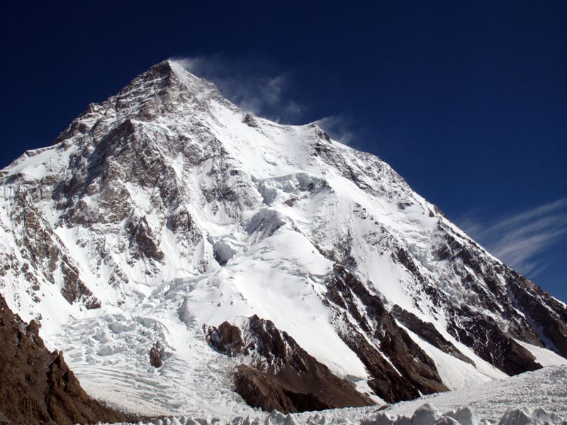
- K2 base camp
- Everest base camp
- Everest base camp via Gokyo
- Everest base camp in a week
- Annapurna circuit
- Trekking the Manaslu Circuit
- Trekking to Kanchenjunga Base Camp
- Trekking to Kanchenjunga Base Camp (Short)
- Trekking to Kanchenjunga Base Camp (India)
- Trekking to Makalu Base Camp
- Trekking to Annapurna BC
- South America
- Asia
- Africa
- Russia
- Europe
-
See 8000m
-
Adventures
-
Africa
- Tour to Morocco for New Year
- Morocco: Toubkal and the mysteries of the Sahara
- Tour to Eritrea: Dahlak Archipelago and Rashaida Nomads
- Tour to Rwanda: Mountain Gorillas and Mount Bisoke
- Ethiopia
- Tour to Uganda: Queen Elizabeth National Park and Mountain Gorillas
- Safari Tanzania
- Safari Uganda
- Tour to Zimbabwe and South Africa: Victoria Falls, Cape Town, and Cape of Good Hope
- Namibia
- Safari Kenya
- Tour to Botswana: Okavango Delta and Chobe National Park
- South America
- Asia
-
Africa
- Ski-touring
- VIP
- Useful
- About
Trekking to K2
- Height (m)
- 5700
- Duration
- 18 days
- Difficulty
- High
- Continent
- Asia
- Children
- From 14 years old
- Accomodation
- There are tents
3700 $
Why to go with us?
There are only 14 eight-thousanders in the world, five of which are located in Pakistan. Four of them - the famous K-2, Broad Peak, Gasherbrum-1 (Hidden Peak), Gasherbrum-2 - are located in the mountain system of Karakorum. The fifth - Nangaparbat - refers to the Himalayas. The trip will allow you to see all five Pakistani eight-thousanders. We will visit base camps of four of them. We will see Nanga-Parbat very close from Karokoram highway if we travel to Scardu by ground.
*Please note that our company does not work in the field of buying, selling air tickets and issuing visa permits, therefore it is not responsible in case of force majeure related to flights and crossing borders.
Important information:
Наверх- When choosing insurance, please note that your insurance must include a helicopter with the amount of coverage for evacuation by helicopter from $ 40,000, a helicopter in Pakistan costs $ 37,000.
About the tour
Along the way, we will be treated to fantastic views of some of the world’s most famous technical peaks — the Trango Towers, Cathedral, and Muztagh Tower, Masherbrum (K1), Bahordas, Uli Biaho, Paiyu Peak, Gasherbrum IV, as well as Chogolisa — some of which rise only slightly below 8,000 meters. Our route will also pass through the unique point where three of the world’s greatest mountain systems meet: the Karakoram, the Himalayas, and the Hindu Kush.
You will immerse yourself in the culture of Pakistan, traveling from Islamabad (where we will visit one of the largest mosques in the world) to some of the most remote villages in the region. Upon returning to Islamabad, you can continue exploring Pakistan by visiting its major cities — Karachi, Rawalpindi, and Lahore.
All of this is part of our unique trekking program to K2 Base Camp in Pakistan!
Trekking to K2
Day 1. Arrival in Islamabad, our representative will meet you at the airport, transfer to the hotel. Then, in the afternoon, a mandatory briefing at the Ministry of Tourism of Pakistan. Also in the evening, a welcome dinner, acquaintance with the rest of the trekking participants and a guide. Dinner and instructing the group. Overnight at the hotel.
Day 2. Flight to the city of Skardu (about 1 hour) – the capital of traditions and, of course, mountaineering in Pakistan. It is in this region that four of the fourteen eight-thousand meters that we will definitely see in the track are located. Legend has it that the city was once called Iskandria and was founded by Alexander the Great. Overnight at the hotel.
Day 3. Transfer to the village of Ascole (3050 meters) . In the morning we get on the jeeps and start an unforgettable trip to the beginning of trekking (moving time 6-7 hours). The Shigar Valley is known for its numerous orchards. Along the way along the Braldo River, you can enjoy views of Mango Guzor and Bakkhor Das with a height of about 6000m. Askole village is the last stronghold of civilization on the way to K-2. Here we meet our porters and distribute the luggage. Overnight in tents.
Day 4. Ascole (3050 meters) — Jula (3300 meters). Early in the morning we start our first day of trekking. Following the Braldo River, we pass the village of Ascole. And then three hours later we reach Korofan and two hours later we arrive at the Jula camp. Our trekking team leaves a little earlier than us to put up tents and cook dinner by the time we arrive at the camp. Overnight in tents. The climb is 250 meters. The distance is 12 km on foot. Travel time is 5 hours.
Day 5. Jula (3,300 meters) — Payu (3,580 meters). Trekking through hilly terrain, sometimes with a narrow path paved along the cliffs. The trail climbs up to a place with a view of the Baltoro Glacier. In the East there is an unforgettable panorama of the Pulpit and Broad Peak towers. Payu camp is located in a small grove of willows and poplars, a stream with fresh water flows through it. The climb is 280 meters. The distance is 18 km on foot. Travel time is 7 hours.
Day 6. Rest day at Payu camp at an altitude of 3580 meters. Overnight in tents.
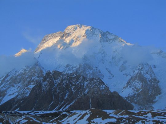
Day 7. Payu (3580 meters) — Coburtse (3900 meters). An hour and a half after leaving, we reach the Baltoro Glacier. This is one of the largest glaciers on Earth, stretching for 62 km and having an area of more than 750 thousand square kilometers. The glacier is covered with rocks, so no special equipment is required to move along it. Constantly gaining altitude for three hours, we come out on the South side of the glacier. Along the way, we see impressive views of Payu Peak, the granite towers of the Trango massif with the Nameless Tower rising to a height of 6,300 meters. The Coburtse camp is located on a flat sandy area at the edge of the glacier. The climb is 320 meters. The distance is 14 km on foot. Travel time is 7 hours.
Day 8. Coburtse (3900 meters) — Urdukas (4050 meters). We continue walking along the moraine for the first two hours. On the opposite side of the Baltoro glacier, there is a view of Payu Peak, Choricho (6648 meters), Uli Biaho, the towers of the Trango massif, Pulpits and Biale (6670 meters). Overnight in tents. The climb is 150 meters. The distance is 6 km on foot. Travel time is 3 hours.
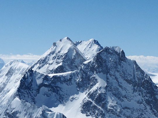
Day 9. Urdukas (4050 meters) — Gora (4380 meters). In the morning we will start trekking along the trail, gently descending down to the middle of the glacier. Along the way, we will admire the views of Masherbrum (7821 meters) and Gasherbrum IV (7952 meters). Overnight in tents. The climb is 320 meters. The distance is 11 km on foot. Travel time is 5 hours.
Day 10. Gora (4380 meters) — Concordia (4650 meters). As you climb, the Gasherbrum-4 (7960 meters) opens with the Gasherbrum-2 peeking out from behind its right slope. More spectacular views await us in Concordia, from where we can see K-2 (8611 meters), Broad Peak, Golden Throne (7316 meters), Metre Peak (6014 meters) and many others. Overnight in tents. The climb is 270 meters. The distance is 15 km on foot. Travel time is 6 hours.
Day 11. Gora (4650 meters) — K-2 Base Camp (5100 meters). We will start the day early in the morning, overcoming several streams created by meltwater. The main part of the route will pass through the glacier from Henry Godwin-Austin, named after one of the first explorers of this region and the first person who was able to measure the height of K-2. The peak itself once bore his name. After arriving at the camp and having a little rest, we go to the Gilki memorial, where for many years traditionally they have nailed plaques with the names of those climbers who died on K-2. Overnight in tents. The climb is 450 meters. The distance is 12 km on foot. Travel time is 5 hours.
Day 12. Base camp K-2 (5,100 meters) — Concordia (4,650 meters). Descent along the already known trail to the Concordia camp. Overnight in tents. The descent is 450 meters. The distance is 12 km on foot. Travel time is 4 hours.
Day 13. Concordia (4650 meters) — Ali (4800 meters). An easy trekking day, during which we will reach Ali’s camp, named after a guy from a nearby village. It is believed that he was the first to overcome Gondogoro. In the evening, we will have enough time to practice our climbing skills to cross the pass. Overnight in tents. The climb is 150 meters. The distance is 10 km on foot. Travel time is 4 hours.
Day 14. Ali (4800 meters) — Gondogoro La (5600 meters) — Khuspang (4600 meters). Very early ascent to cross the Gondogoro Pass (La). It usually takes about three hours to reach the top, and in good weather we will have a view of the highest mountains in this region, including K-2, Broad Peak, Gasherbrum I, II and IV. We will walk most of the way on fixed ropes in cats and on insurance. After the pass, a pleasant path along the Gondogoro Valley awaits us, which will lead us to the Khuspang Valley with small lakes and green grass. Overnight in tents. The climb is 1200 meters, the descent is 1000 meters. The maximum height is 5,600 meters. The distance is 10 km on foot. Travel time is 9 hours.
Day 15. Khuspang (4600 meters) — Saicho (3350 meters). We will continue the hike through the pastures of Gondogoro, where you can see temporary shelters made by shepherds from stones. Soon we will cross a small stream before reaching a side moraine that descends into the lowlands of the Gondogoro Valley, where our next camp is located. After almost one week at an altitude of more than 4,000 m, “oxygen-rich” air will finally be available, and participants will be able to sleep under the lulling murmur of a glacial river. Overnight in tents. The descent is 1250 meters. The distance is 16 km on foot. Travel time is 6 hours.
Day 16. We are going to Skarda by jeeps. The 6-8 hour trip passes through many picturesque villages. This part of Baltistan is greener and more prosperous than on the way to Ascol. And in Skardu, a comfortable hotel and a hot shower will be waiting for us. In the evening — a festive dinner in honor of the successful end of trekking! Overnight at the hotel.
Day 17. Flight back to Islamabad. Overnight at the hotel.
Day 18. Flight home.
Price of trekking K2 expedition includes:
- Guide
- Meet and greet / airport transfers
- 2 nights in Islamabad in a hotel with breakfast
- 2 nights in Skardu in a hotel with breakfast
- Transport Islamabad – Skardu – Islamabad
- Jeep transport Skardu – Askole (Hushe) – Skardu
- Wages for local guide, cook, and porters during the trek
- Local taxes and insurance for guides and porters
- Meals during the trek (breakfast/lunch/dinner)
- Mules and porters for transportation of group and personal luggage (up to 12 kg per person)
- Road and bridge crossing fees
- Mandatory briefing and debriefing at the Pakistan Ministry of Tourism
- All necessary documentation and permits
- Tents and sleeping mats during the trek
- Airport–hotel–airport transfers
Price of trekking K2 expedition does not include:
- Lunches and dinners in cities
- Personal expenses, tips and drinks
- Medical insurance, medical expenses and expenses for rescue work (insurance must include a helicopter with the amount of helicopter evacuation coverage starting from $40,000, a helicopter in Pakistan costs $37,000)
- Hot shower
- Any expenses related to political instability and natural disasters
- Visa to Pakistan and international flight
- Any costs associated with changes to the program
- Application form from the embassy’s website filled out in English (3 copies)
- 4 photos (parameters not specified)
- Visa support (sent by Pakistani partners)
- Return ticket
- Certificate from work in English
- Copies of the passport and the Russian passport.
- Any costs caused by the changing of the programs
Insurance
НаверхList of equipment
Скачать PDFDocuments:
- Passport
- Plane tickets
- Medical insurance
- Questionnaire from the embassy’s website filled out in English (3 copies)
- 4 photos (color 3*4)
- Copies of the passport and Russian passport
Personal equipment:
- Backpack 50-60L.
- Sleeping bag, comfort temperature -10C.
- Trekking poles.
- Crampons
- A classic ice axe with a steel beak or an ice tool.
- Climbing system.
- Carabiners – 5 pcs.
- Self-insurance mustache.
- Trigger device.
Clothing and shoes:
- Single-layer climbing boots.
- Sneakers (for cities).
- Waterproof layer – Jacket + trousers. The industry offers a range of products from simple 5000/5000 membranes to Gore-Tex products.
- Fleece suit.
- Thermal underwear top + bottom.
- The mittens are warm.
- The gloves are thick.
- The gloves are thin.
- Bandana (in addition to sun protection in the valley, it can be used to insulate the throat or face in the cold)
- Warm trekking socks for climbing day
Various:
- A diode flashlight on the head
- Sunglasses
- Ski mask-glasses
- Thermos – 1L. Preferably without a button in the lid.
- Windproof mask on the lower part of the face
- Leggings
- Sun cream, hygienic lipstick
- Chemical hot water bottles (optional, but may be very useful)
- Personal first aid kit
- Elastic bandage and/or supportive bandage.
You may also like
-
 39,000 $
Climb Broad Peak
- Height (m)
- 8051
- Duration
- 51 day
- Difficulty
- Above average
- Continent
- Asia
- Children
- From 14 years old
- Accomodation
- There are tents
-
 39,000 $
Climb Gasherbrum I and II
- Height (m)
- 8034, 8080
- Duration
- 61 day
- Difficulty
- Average
- Continent
- Asia
- Children
- No
- Accomodation
- There are tents