- Guides
- B2B
-
#19607 (no title)
-
#15972 (no title)
- Climb Elbrus Individually
- Climb Elbrus from the South, 9 Days
- Climb Elbrus from the South, 7 Days
- Climb Elbrus from the South with Oxygen
- Climb Elbrus from the North, 10 Days
- Two Summits of Elbrus, 9 Days
- Elbrus Traverse from South to North, 9 Days
- Elbrus Traverse from North to South, 10 Days
- Cross of Elbrus, South to North, 9 Days
- Cross of Elbrus, North to South, 10 Days
- Climb Kazbek and Elbrus — 10-Day Two-Summit Expedition
- Climb Elbrus from the West, 11 Days
- Elbrus by Private Helicopter, 3 Days
- Elbrus Region Holiday and Trekking, 9 Days
- Elbrus Region Holiday, 7 Days
- Elbrus Dating
- Climb Elbrus from the South, 9 Days with Sergey Baranov
-
#15539 (no title)
- Climb Carstensz Pyramid, 8 Days with Helicopter Access
- Climb Mont Blanc, 4810 m — 8-Day Guided Ascent
- Climb the Matterhorn, 4478 m — 8-Day Guided Ascent
- Climb Mount Vinson, 15-Day Antarctic Expedition
- Climb Kosciuszko and Travel in Australia, 7 Days
- Climb Fisht, 2868 m — 3-Day Ascent by the 1B Route
- Climb Mount Wilhelm, 6 Days
-
#15546 (no title)
- Climb Kilimanjaro: the Marangu Route
- Climb Kilimanjaro: the Lemosho Route
- Climb Ararat, 5137 m — 7-Day Classic Climb
- Climb Kazbek from the South, 5033 m — 8 Days in Georgia
- Climb Kazbek and Elbrus — 10-Day Two-Summit Expedition
- Climb the Volcanoes of Mexico — Orizaba and Iztaccíhuatl, 9 Days
- Climb Alpamayo — 16-Day Technical Expedition
- Climb Margaret Peak (Stanley), 5109 m
- Climb Mount Kenya: Point Lenana, 4985 m
- Climb Dykh-Tau by the North Ridge, 13 Days
-
#15554 (no title)
- Aconcagua Climb — 17-Day Guided Expedition
- Island Peak Climb — 18-Day Expedition
- Climb Mera Peak, 6476 m — 16-Day Hinku Valley Expedition
- Climb Ama Dablam, 6812 m — 24-Day Expedition with Island Peak
- Climb Island Peak and Mera Peak — 24-Day Two-Summit Expedition
- Aconcagua and Ojos del Salado — 25-Day Combined Expedition
- Ojos del Salado Climb — 15-Day Expedition
- Climb Chimborazo and Cotopaxi — 14-Day Ecuador Expedition
- Climb Huascarán — 8-Day Technical Ascent
- Climb Razdelnaya Peak, 6148 m — 15-Day Pamir Expedition
- Climb Denali by the West Buttress, 23 Days
- #15565 (no title)
- #15572 (no title)
-
#15972 (no title)
-
#19592 (no title)
-
Trekking in Nepal: routes to the eight-thousanders
- K2 Base Camp Trek via the Gondogoro La
- Everest Base Camp Trek — 14 Days
- Everest Base Camp via Gokyo Lakes — 15 Days
- Short Everest Base Camp Trek in 10 Days
- Annapurna Circuit and Tilicho Lake Trek
- Manaslu Circuit Trek
- Kanchenjunga Circuit Trek (XXL)
- Kanchenjunga North Base Camp Trek (Short)
- Kanchenjunga from India: the Goecha La Trek in Sikkim
- Makalu Base Camp Trek
- Annapurna Base Camp Trek
- Trekking in South America
- Asia
- Trekking in Africa
-
Trekking in Russia
- Elbrus Region Holiday and Trekking, 9 Days
- Elbrus Region Holiday, 7 Days
- Oshten + Kardyvach — 9-Day Western Caucasus Trek
- Lake Kardyvach — 5-Day Base-Camp Trek
- Route 30: Through the Mountains to the Sea, with Oshten — 4 Days
- Trekking in Arkhyz — 7 Days over the Ayulyu Pass
- Gvandra Trek — 7 Days to the Ullu-Kyol Lakes
- Trekking in Dombai — 7 Days with the Murudzhu Lakes
- Europe
-
Trekking in Nepal: routes to the eight-thousanders
-
Adventure expeditions
-
Trekking in Africa
- モロッコツアー:北アフリカの中心
- トゥブカルの登山とモロッコの文化
- Eritrea: the Dahlak Archipelago and the Rashaida Nomads
- Rwanda: Mountain Gorillas and the Bisoke Volcano
- Ethiopia: Otherworldly Landscapes and the Peoples of the Omo Valley
- ウガンダツアー:クイーンズパークとマウンテンゴリラ
- Tanzania Safari: Serengeti, Ngorongoro and Tarangire
- ウガンダツアー:ホワイトサイとマウンテンゴリラ
- Zimbabwe and South Africa: Victoria Falls, Cape Town and the Cape of Good Hope
- Namibia: Etosha National Park and the Himba
- Kenya Safari: the African Big Five
- ボツワナツアー:オカバンゴデルタとチョベ公園
- Trekking in South America
- Asia
-
Trekking in Africa
- Ski touring and ski mountaineering: chasing freedom in the mountains
- VIP tours
- #19722 (no title)
- About
Kanchenjunga from India: the Goecha La Trek in Sikkim
- Height (m)
- 4984
- Duration
- 14 days
- Difficulty
- Moderate
- Continent
- Asia
- Children
- Ages 14+
- Accommodation
- Some nights in tents
2880 $
Why to go with us?
Temporarily unavailable
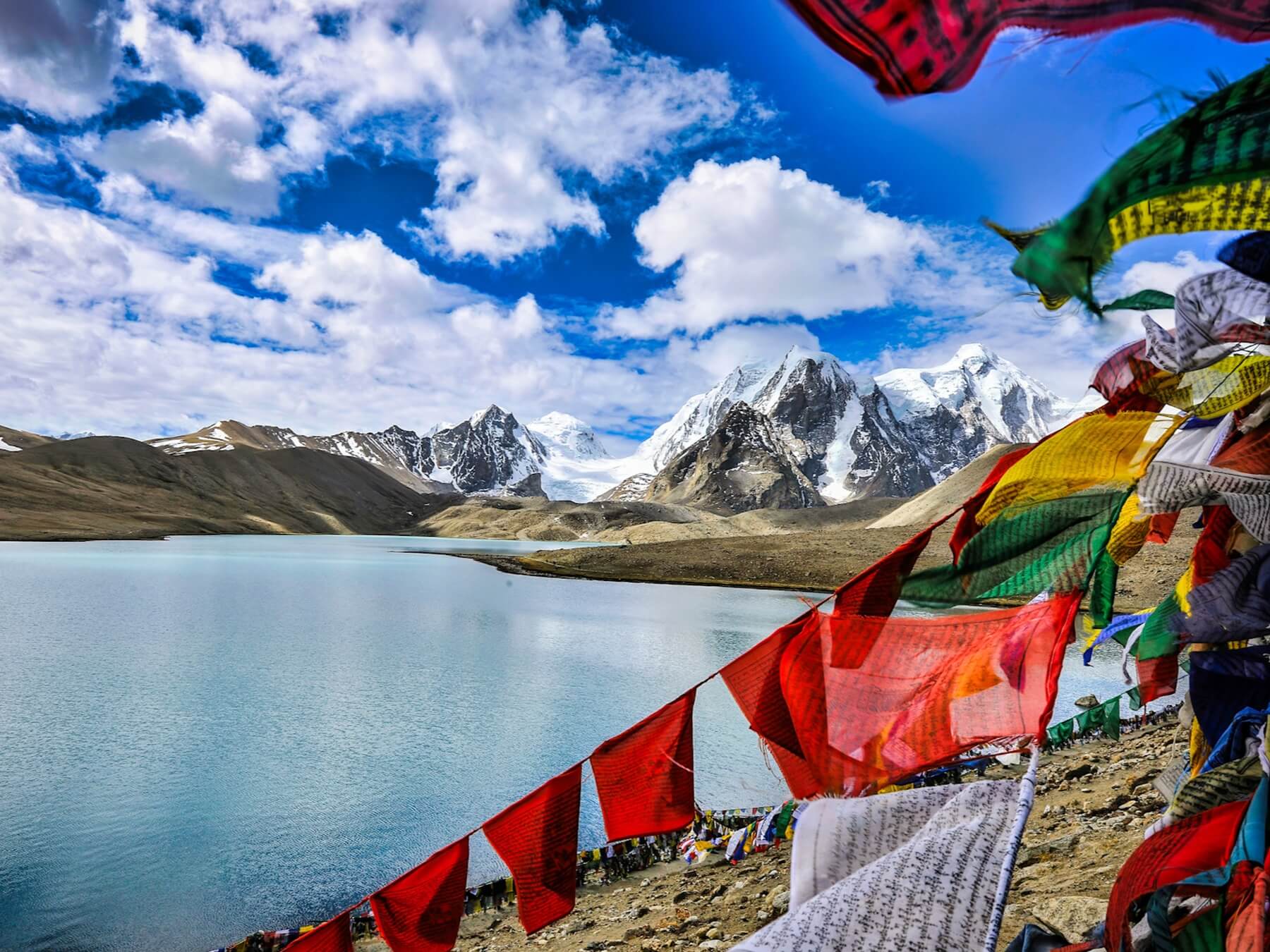
The Goecha La trek to Kanchenjunga in India is a fourteen-day trip in Sikkim through Yuksom, Tshoka, Dzongri, Thangsing, Lamuney and the high viewpoint facing the massif.
The route is often sold as "Kanchenjunga Base Camp", and it is important to be precise about this: the trip follows the Indian Dzongri – Goecha La trail and does not visit the expedition base camp on the Nepali side. The main objective is close views of Kanchenjunga, Pandim, Kabru and Rathong.
The guide helps to control acclimatisation, explains how the local team works and accompanies the group from the city days through to the high-altitude section. No technical mountaineering experience is required, but you do need experience of multi-day walking, good physical condition and a readiness for nights under canvas.
Important. The price is fixed in US dollars. The highest point actually reached depends on permits, on the state of the trail and on the guide's decision. Mountain Guide does not sell air tickets and does not arrange visas.
About the Goecha La trek in Sikkim
Kanchenjunga, 8586 m, is the third-highest mountain in the world. From the Indian side the official high-altitude route to the massif runs through Kanchenjunga National Park: Yuksom, Tshoka, Dzongri, Thangsing, Lamuney and the Goecha La area. It shows the eastern side of the mountain, but it does not coincide with the expedition approaches in Nepal.
The first days pass through the damp forests of Sikkim and involve a significant gain in altitude. A separate acclimatisation day is provided at Dzongri, with an outing to Dzongri Top. The group then crosses an open ridge, descends to the Prek Chu and climbs through Thangsing to Lamuney. An early start in the direction of Goecha La is the culmination of the trek.
The difficulty of the route lies in the combination of steep forest climbs, a multi-day load and nights above 4000 m. There is no technical climbing, but cold, snow, rain and a slippery trail are all possible. Participants must be able to walk five to eight hours a day with confidence and hold their pace on long climbs and descents.
The actual upper point is determined by the national park permits in force, by the state of the trail and by the guide’s decision. The trip therefore states the direction of Goecha La and the maximum declared altitude, but does not promise passage to a closed or unsafe point.
The standard package includes leadership that reduces the risk of misunderstanding when discussing how participants feel, the pace and any change to the route. Local guides and the ground team provide knowledge of the trail and of the rules of Sikkim.
Itinerary of the Goecha La trek in Sikkim
Day 1. Arrival in Bagdogra and transfer to Gangtok, 1650 m.
A team representative meets the group at Bagdogra airport and arranges the transfer to Gangtok. After check-in we rest, meet the guide and discuss the onward logistics. The day is set aside for recovery after the flight and for a document check before entering the protected districts of Sikkim. Night at a hotel.
Day 2. Gangtok and preparation for the trek.
We visit the accessible sights of Gangtok, including monasteries and cultural centres, then return to the hotel. The order of sites depends on opening hours. In parallel the guide completes the check of equipment and permits, and participants prepare a separate bag for the mountain section. Night at a hotel.
Day 3. Drive to Yuksom, 1780 m.
We drive from Gangtok to Yuksom, the historic centre of Sikkim and the start of the Goecha La route. After check-in you can walk to the coronation site and the accessible monasteries. The task of the day is to reach the start without overloading anyone on foot and to prepare for the first stage. Night in a hut or at the confirmed accommodation.
Day 4. Yuksom to Sachen, 2450 m.
We begin the trek through pine and oak forest, cross bridges over the Prek Chu and climb to Sachen. The stage takes about six hours. The first day lets everyone set a pace, check their footwear and ration their strength before the steeper climb to Tshoka. Night in tents.
Day 5. Sachen to Bakhim to Tshoka, 3000 m.
We continue the climb through Bakhim and forests of magnolia and rhododendron to Tshoka. The stage takes about seven hours and is one of the most tiring forest sections. After check-in it is important to restore fluids and food, because the next day takes the group above 4000 m. Night in tents.
Day 6. Tshoka to Dzongri, 4020 m.
We climb steeply through rhododendron forest and Phethang to Dzongri. About five hours of walking bring the group to its first night above 4000 m. The guide reduces the pace and watches carefully for signs that anyone is tolerating the altitude poorly. Night in a hut or in tents, according to the confirmed arrangement.
Day 7. Acclimatisation in Dzongri.
We stay at Dzongri and, depending on the condition of the group, climb Dzongri Top, from which in clear weather Kanchenjunga, Kabru, Rathong, Kokthang and Pandim are visible. The outing exists for adaptation before Thangsing and Lamuney, not only for the panorama. After the descent we rest and prepare our kit for the rest of the route. Night in tents.
Day 8. Dzongri to Thangsing, 3800 m.
We climb an open ridge to about 4115 m, then descend to the Prek Chu and, after crossing the river, gain altitude again to Thangsing. The stage takes about five to six hours. The alternation of climbing and descending calls for even rationing of effort. Night in tents.
Day 9. Thangsing to Lamuney, 4298 m.
A short stage of about three hours follows the Prek Chu towards Samiti Lake and the Lamuney camp. The short distance preserves reserves before a night or early start and gives extra time to adapt. After check-in the guide announces the permitted upper point and the start time. Night in tents.
Day 10. Outing in the direction of Goecha La, up to 4984 m.
We set out early in the morning for the Zemathang plateau and the viewpoint on the Goecha La route that is accessible on the date of the trip. In clear weather the eastern side of Kanchenjunga opens up. The maximum point depends on permits, on the state of the trail, on the weather and on how participants feel; reaching 4984 m is not guaranteed. After the outing we descend to the Kokchurang camp. Night in tents.
Day 11. Kokchurang to Tshoka.
Following an alternative trail we avoid climbing back onto the Dzongri plateau and make a long descent through forest. The stage takes about seven to eight hours. After the highest point of the route it is important to stay attentive on wet roots, stones and tired legs. Night in tents.
Day 12. Tshoka to Yuksom.
We continue the descent to Yuksom; the stage takes about five to six hours. The self-supported part of the route ends here. After check-in participants shower, sort out their baggage and recover after several walking days. Night at a hotel.
Day 13. Yuksom to Darjeeling.
In the morning there is a walk to the Dubdi monastery and the historic site in Yuksom, after which we drive to Darjeeling. The declared road is about 95 km and five hours. The day links the trekking with the cultural part and leaves the evening free. Night at a hotel.
Day 14. Transfer to Bagdogra airport.
After breakfast we say goodbye to the team and drive to Bagdogra airport. The declared road is about 90 km and three hours, so we recommend choosing a flight after 14:00 and confirming it with Mountain Guide before purchase. Participants check in on their own at the airport.
What's included
- A Mountain Guide team leader with groups of four participants or more
- A local guide for groups of one to three participants
- Meeting and seeing off at the airport
- Hotel accommodation – the number of nights according to the itinerary
- Breakfasts in the hotels before and after the trek
- Accommodation in lodges and tented camps according to the itinerary
- Three meals a day and hot tea or coffee during the trek
- Vegetarian meals during the trek
- Boiled drinking water on trekking days
- The necessary permits, authorisations and national park entry fees
- Entrance tickets to the sightseeing sites in the itinerary
- Group equipment, a basic medical kit and a first aid kit
- Kitchen, dining and toilet tents on the stages where they are needed
- A sleeping bag – bringing your own is recommended for reasons of hygiene
What's not included
- International flights
- An Indian visa or any other entry permit the participant requires
- Medical insurance and the cost of emergency evacuation
- Lunches and dinners while staying in the city hotels
- A personal porter – $25 a day for baggage up to 20 kg; two participants usually share one porter, and porter insurance is included in that rate
- Single occupancy
- Early hotel check-in and late check-out before or after the trip
- Tips for the local team
- Additional costs if the itinerary is changed or not followed
- Costs arising from cancellations, weather, illness, damage to property and other unforeseen circumstances
Private groups
The trek to Kangchenjunga in India can be arranged for a closed group of friends, a club or a corporate team, with no one else joining. Dates, the make-up of the guiding team and any extra services available on the route are agreed individually. For a closed group we can discuss your own dates, the working language, a personal porter, single rooms in the towns and extra days in Sikkim. Access to the area and the set of permits required are checked for each participant’s nationality. The acclimatisation days, the nights at altitude and the order of the stages are not shortened. Whether teenagers can join is assessed case by case, taking account of altitude, the length of the trek and readiness for the tented stage. The price depends on the number of participants, the dates you choose, the make-up of the team and any extra services confirmed.
Documents you need
Document requirements depend on your nationality and can change. Check them before you buy non-refundable tickets, and again before you fly. The first name and surname on every booking must match the spelling in your passport exactly. Mountain Guide does not sell air tickets and does not arrange entry visas, but it does provide the booking confirmations it holds and the documents issued by the host team.
Documents
- A valid passport
- A visa or other entry permit for India, if one is required for your nationality
- International and domestic air tickets, or e-ticket receipts, for the trip
- Medical insurance covering high-altitude trekking, a maximum altitude of at least 4984 m, search and rescue and emergency evacuation
- Your insurance policy number and the insurer’s 24-hour emergency contact details
- Your booking confirmation for the trip and the organisers’ contact details
- Passport copies and photographs in the format requested for Sikkim permits
- Any further details required to admit a foreign national to a restricted area
- Documents for a participant under 18, where these apply
- Digital copies of your passport, visa, tickets and insurance on your phone and in cloud storage
- Waterproof wallet for your original documents
The permits for the confirmed route are arranged by the host team as part of the services included. Which documents are needed depends on your nationality, so copies must be supplied by the deadline the organisers set.
Weather and seasons
Treks in Sikkim usually use the spring and autumn periods. India’s official tourism portal gives March to May and September to mid-December as the periods for walking in the mountains of this region. The dates you choose must take account of permits and the state of the high-altitude trail. The lower sections pass through humid forest, where rain, mud and mist are all possible. Wind and cold increase above the treeline; around Dzongri and the higher points there can be snow, ice and sub-zero night temperatures. The views of Kangchenjunga depend on the cloud and are not guaranteed. Your local guide may change the start time, shorten an out-and-back outing or turn the group round if the weather, the state of the trail or a participant’s condition deteriorates.
Accommodation and meals
Hotel accommodation is provided in the towns for the number of nights in the itinerary, with breakfasts included before and after the trek. The specific properties and room category are confirmed before the trip. Single occupancy is paid separately. The route uses lodges, and a tented camp on the stage around Dzongri. Where necessary the local team sets up kitchen, mess and toilet tents. A sleeping bag is provided where one is available, though for reasons of hygiene we recommend bringing your own, which you know and trust. Breakfast, lunch, dinner, hot tea or coffee and boiled drinking water are included during the trek. Lunches and dinners at the hotels before and after the mountain section are paid separately. A vegetarian menu is available. Tell us about other dietary restrictions and allergies before booking, so the host team can confirm what can be substituted.
Facilities on the route
Showers and hot water. Town hotels have the usual facilities. Hot water in the lodges may be available on request and is not always included in the price. A regular shower is not guaranteed at the tented camp.
Toilets. Conditions vary from lodge to lodge. On the camping stage a toilet tent is put up where necessary. For a night start you need a head torch and footwear you can put on quickly.
Power and charging. Plan on charging your devices reliably in the towns. On the trek, charging may cost money, be slow, or not be available at all. You will need a power bank and spare batteries.
Internet and phone signal. Mobile signal and internet are unreliable in the remote parts of Sikkim. On the high-altitude section there may be long stretches with no phone coverage. Satellite devices must not be brought into India without checking separately whether they are permitted.
Laundry and drying. Plan on doing proper laundry before or after the trek. In the forest zone things can take a long time to dry, so bring spare dry clothing and waterproof packing.
Insurance
НаверхEquipment list for the trek to Kangchenjunga Base Camp (India)
Скачать PDFYou bring all of your own personal equipment. Before the trip, agree your footwear, sleeping bag and personal kit with the guide, taking the season and the conditions on the route into account.
Documents
- Passport
- Air tickets or e-ticket receipts
- Medical insurance covering helicopter evacuation
- We recommend keeping digital copies of your documents on your phone and in cloud storage
Personal equipment
- Rucksack of 30-50 litres
- Duffel bag for personal items (our team provides one locally)
- Sleeping bag with a comfort rating of -5 °C
- Trekking poles, which must have baskets
Clothing and footwear
- Trekking boots, thoroughly treated with a waterproofing product beforehand
- Trainers (for town)
- Waterproof membrane shell: jacket and trousers
- Fleece top and bottoms
- Base layer, top and bottoms
- Down jacket with a hood
- Thick gloves
- Thin gloves
- Bandana or buff (as well as sun protection in the valley, it can keep your throat or face warm in the cold)
- Warm hat
- Warm trekking socks
Other items
- LED head torch with at least 12 hours of battery life
- Power bank
- Sunglasses
- Rain jacket
- Rain cover for your rucksack
- Vacuum flask or water bottle, 1 litre
- Gaiters
- SPF 50 sun cream
- SPF 10-15 lip balm
- Personal first-aid kit
- Elastic bandage and/or a support brace
- Toothpaste, toothbrush, soap, shampoo and flip-flops
- Towel
- Toilet paper (on sale in the lodges along the way)